Beding is a nice place to hang out.
What to do in Rolwaling There are countless opportunities for exploration and relaxation in the valley. Here are a few of our favorites:
- Beding gompa No stay in Beding is complete without a visit to the small Gompa situated at the beginning of town. The thankas inside the Gompa were painted in 1960 by the famous artist, Kappa Kalden from Khumbu. Although the external displays near the entrance are in poor condition, the interior paintings have been well preserved. The northern wall of the Gompa is filled with the books of the Kangul and Yum, which were carried from Tibet after being printed in 1944. If you are lucky, you may be able to witness one of the numerous festivals that take place at the gompa each month. Two new gates were built in 2001 which frame each side of the courtyard and enclose the gompa compound. The lamas request that pictures are not taken inside. As with all of nepals gompas, donations are expected.
- Chamgang retreat (45 minutes up from Beding) And when we say "up," we mean UP! What a spectacular view!
Perched in the cliffs above Beding, Chamgang is a small meditation retreat presumably intended for one monk. The building was constructed and financed by Lama Nawang Tembi, with help from local villagers.
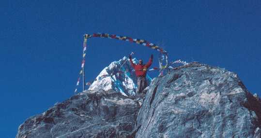
The path up to the retreat is ambiguous, particularly in the lower reaches. You should probably ask someone: Chamgang-jaane bhaato kaha chha? Or just start above the gompa and head toward the yellow prayer flag. The path skirts the left side of the major rock buttress before crossing below the flag and continuing along the wide ledge to the small white building. From here there are excellent views up and down the valley. The three major peaks that make up the southern valley wall are all over 5,500 meters. From east to west (left to right), they are Yalung Ri, Dorje Phagmo and Tabayabyum. If the weather is clear, late evening offers impressive displays of alpenglow on these craggy peaks.
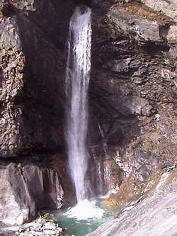
- Waterfalls (10 min. east, 20 min. west) Also in close proximity to Beding are several photogenic waterfalls. One can be reached by a short walk to the upper (east) end of the village and following the stream that powers the little watermill. This is probably your best option for getting some privacy when you bathe... although you might keep an eye out for leering goatherds in the brush above you.
Another impressive cascade cuts into the rock above the suspension bridge at Chameka (Nyimare), 20 minutes west of Beding. You can scramble up to the cirque above the falls by staying close to the eastern edge of the steep valley and finding a little used path. The stream which originates on the southeast face of Gauri Shankar plunge through the rifted escarpment is known as Jomo'i Gul Chhu: "the Lady's Piss Stream" -- the Lady in question being Jomo Tseringma, aka Gauri Shankar.
To reach the top of the falls and the cirque at the base of Gauri Shankar, begin by leaving Chameka through the upper fields on the hill by the great tree surrounded by mani stones. Head northeast up the slope toward the steep cliff face that forms the right hand side of the valley. With any luck, you should intersect the trail at some point. If not, continue alongside and under this cliff before eventually breaking left across the gullies and toward the few lone trees on top of the slight ridge. Make your way through the thick juniper bushes and down to the river before hiking up into the cirque. Note the three large boulders immediately before the river pours into the slot: this is where you will need to regain the ridge on the return trip. On a clear day, this hike offers views directly up the steep ice and rock walls that form the Tibetan border. From some vantage points, it is also possible to stare up the imposing southeastern flanks of Lady Tseringma.
- Menlung Another possible hike from Beding is toward the Menlung La. The trail breaks left off of the main trail several hundred meters up the valley from Beding. The steep climb gains a lot of altitude, making acclimatization important. Those that have already been to Na or higher shouldnt have problems. This hike brings you to the Glacier below the Menlung La. It was over this high pass that Rolwaling locals traditionally carried out their trade with Tibet before the Chinese closed the borders in 19--. They would trade yaks, salt, wool, rice, and other goods between Tibet and India. This is also the sight where Eric Shipton spotted the Yeti in 1951 and took his famous photographs. His was the first western sighting of the elusive creature and sparked the hype surrounding its controversial existence that continues to this day. The border is still officially off limits to tourists, and it is possible that even a trip close to the pass could be considered illegal. However, for those willing to take the risks, and for those with the proper equipment and knowledge of glacier travel, it could be possible to reach the border or cross into Tibet at this point.
- Na One and a half hours up the valley from Beding is the last major settlement, called Na. This village is the oldest in Rolwaling and was the main settlement before the agriculture shifted its focus from barley to potatoes. Once the potatoes were introduced, cultivation became possible at lower altitudes and the Sherpas built Beding and the winter settlements. Its fields, lined by several kilometers of rock walls, still produce the majority of the valleys crops. While a daytrip to this area is certainly worth the hike, at least a day or two should be spent here to really enjoy all it has to offer. Several options for lodging exist, though it is best to ask in Beding. The three main attractions are Omai Tso, Tsho Rolpa, and the meadows below the Yalung La.
- Omai Tso Omai Tso (Milk Lake) is a beautiful small alpine lake that offers excellent views of massive mountains. This little gem is sacred to both Buddhists and Hindus. Numerous Hindus from the lowlands make a yearly pilgrimage to this lake to worship Bhoudou on August 1. Buddhists believe the lake is inhabited by invisible spirits which are half man and half serpent. These Lu inhabit all large bodies of water and bring good fortune. The Valleys Sherpas hold a festival here in mid-summer. The fluttering prayer flags and small chortens add to the spiritual and photogenic quality of the area, while the massive mountains of the Nepal-Tibet border are reflected in its still waters. In addition to visiting the lake for spiritual purposes, the Sherpas spend several weeks each year in the small yak camp at the far side of the lake as well as another one, located farther up the valley. To get there follow the trail out of Na and across the bridge. Continue up the valley to a second bridge at the base of the glacial moraines (about 1 hour). Immediately after crossing this bridge, head left following numerous faint trails and cairns up the terminal moraines of the Ri Pimo Shar Glacier to the small lake on the left edge of the glacier. This is a good half-day trip from Na and the perfect picnic spot. As with all areas of the valley, please keep the area clean and keep its sacred nature in mind.
For the energetic, it is possible to make an ascent of the ridge (Ri Pimo) just north of the lake. This ridge is straightforward and offers outstanding 360 degree panorama of the area. Gain the ridge by heading up the steep slopes from the far northern end of the lake. Continue up the ridge as far as you see fit. In addition to offering outstanding views, this is an ideal acclimatization hike for those heading over Tesi Lapcha or up one of the valleys high peaks.
- Tsho Rolpa It is also possible to combine a trip to Omai Tso with a visit to Tsho Rolpa. This giant glacial lake has received a great deal of press in recent years. Fear that this lake may breach its natural dam and flood the valley below has lead to a much international intervention. While previous attempts to siphon the water from the lake have failed, a current program which employs a series of deep trenches cut in to the terminal moraine, has lowered the water level slightly. Still, the danger for an outburst exists. Early warning sirens have been installed in villages throught rolwaling and the tamba kosi valley far below. The buildings and signs at the edge of the lake detail some of this information. To get there from Omai Tso, walk along the far lower end of Ri Pimo Shars terminal moraine, eventually meeting up with the main trail before heading up past the large boulder on top of the ridge. Be especially careful when crossing the moraine. The steep sides are extremely unstable and any attempt to take a short cut could trigger a landslide. Instead be prudent and find a gradual and stable point that can be crossed safely. The large cairn and prayerflags have been dubed Dutch Rock after the ...... efforts to solve the Tso Rolpa problem. Trekkers are encouraged to add more stones to this monument to ..... From Na, the trail to Tsho Rolpa breaks right after the second bridge and follows the well-worn trail to the lake.
- Yalung La and Ramdung Basecamp The trail to Yalung La is a steep, 700m climb, but well worth the difficulty. It yields breathtaking views of the surrounding mountains and amazing sunsets. After crossing the first bridge from Na, be on the lookout for a small cairn and a faint fork in the trail (20-30 min). The trail leads up the steep valley via switchbacks, passing a small summer yak herding camp (1¾-2½) where the trail crosses a small stream. Continue west past several small cairns before continuing southward up the valley. From here, 30-45 minutes brings you to a small flat area that the trail crosses before heading up to a large flat dry lakebed (30-45 min). While the valleys below fill with afternoon fog, this vantage point regularly remains high above the cloud tops, rewarding the hiker with stunning sights. The garbage scattered in the sand marks the Yalung/Ramdung basecamp and illustrates one of tourisms uglier sides. It is best to reserve a full day for this trip. Even if you dont make it all the way, the views are great from any height. From the dry lake, it is possible to explore the numerous high rocky ridges. Those with the proper equipment can use this basecamp to stage an ascent of Yalung Ri. This 5630m peak is a straightforward snowclimb up a small glacier culminating in an impressive technical summit ridge. This mountain should only be attempted by experienced mountaineers with proper equipment. This area also serves as the basecamp for those attempting to climb Ramdung Go, one of the valleys two trekking peaks. An ascent of this mountain requires a peak permit and guides.
- Na In Na there are a few sights worth a visit. The valleys first Gompa was originally built in Na, but unfortunately it has fallen into disrepair. However, valley residents have raised enough money to rebuild the Gompa and construction is planned to be complete by June 2002. High up on the hillside at the western end of town is the Na meditation place, visible by its numerous prayerflags. The large rock under which the retreat is built is known as Urgen Drokang, thought to be a spontaneously created likeness of Guru Urgen Rinpoche. Below the meditation place, painted on a large flat rock, is a picture of Guru Urgen Rinpoche. And below this painting are several large mani stones which were also visited by the Rinpoche on his way through the valley and into Tibet. The large square stone is known as Urgen Shuti and is believed to be the chair of the Rinpoche during his stay in the valley.